File:Screen Shot 2017-08-12 at 12.03.07 PM.png
From Wooljersey
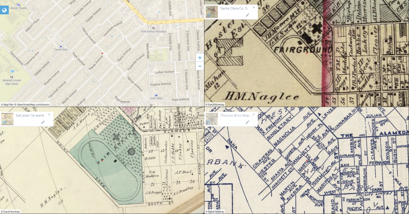
Revision as of 21:05, 6 October 2021 by Morgan (talk | contribs) ([http://www.georeferencer.com/compare#657767256175 Location of the race track in San Jose], per [http://davidrumsey.georeferencer.com/maps/eb1350d8-e91e-5d0f-9098-936437c146c6/?_gl=1*bkbt8e*_ga*MTcwMzQ3OTM1Ny4xNjI4MzU3MTI2*_ga_W4NH1B56KN*MTYzMzU1Mzc3NS4yMi4xLjE2MzM1NTQxOTUuMA.. (Farm) map number five (Santa Clara Co., California). (Thompson & West, San Francisco, Cala. 1876)] and [http://davidrumsey.georeferencer.com/maps/63f5051e-589a-5152-b035-fd96d3a50200/?_gl=1*bkbt8e*_ga*MTcwMzQ3OTM1Ny4x...)

Size of this preview: 800 × 419 pixels. Other resolution: 3,360 × 1,758 pixels.
Original file (3,360 × 1,758 pixels, file size: 8.82 MB, MIME type: image/png)
Summary
Location of the race track in San Jose, per (Farm) map number five (Santa Clara Co., California). (Thompson & West, San Francisco, Cala. 1876) and City of San Jose, first ward. (Thompson & West, San Francisco, Cala. 1876)
Garden City Cyclers H M N Spring pres, Geo W Pollard rec sec, H A Alexander fin sec, San Fernando bet 1st and 2d
Garden City Cyclers' Race Track, The Alameda bet Race and Henry place
File history
Click on a date/time to view the file as it appeared at that time.
| Date/Time | Thumbnail | Dimensions | User | Comment | |
|---|---|---|---|---|---|
| current | 21:57, 6 October 2021 | | 3,360 × 1,758 (8.82 MB) | Morgan (talk | contribs) | Add 1938 Thomas Bros map |
You cannot overwrite this file.
File usage
The following page uses this file: