Difference between revisions of "Point Lobos road"
From Wooljersey
| Line 15: | Line 15: | ||
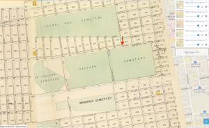
[[File:Screen Shot 2021-02-03 at 7.33.34 AM.png|thumb|center|''The meeting point at the "old toll-gate" would have been at [http://www.georeferencer.com/compare#921121335787 what is now Geary and Presidio], illustrated by the red arrow in this 1876 map, according to [https://www.nps.gov/goga/learn/historyculture/upload/Property_Point_Lobos_Toll_Road_sr_2014.pdf Vestiges of Lands End]:'']] | [[File:Screen Shot 2021-02-03 at 7.33.34 AM.png|thumb|center|''The meeting point at the "old toll-gate" would have been at [http://www.georeferencer.com/compare#921121335787 what is now Geary and Presidio], illustrated by the red arrow in this 1876 map, according to [https://www.nps.gov/goga/learn/historyculture/upload/Property_Point_Lobos_Toll_Road_sr_2014.pdf Vestiges of Lands End]:'']] | ||
Pages which link here: | |||
{{Special:Whatlinkshere/Point Lobos road}} | |||
[[Category:San Francisco]] | [[Category:San Francisco]] | ||
[[Category:places]] | [[Category:places]] | ||
Latest revision as of 17:50, 11 June 2023
Point Lobos Road and Calvary Cemetery, 1865 n.d.
Vestiges of Point Lobos Avenue
See Western Neighborhoods Project - point-lobos-gate-1865
From Point Lobos Road, An 1895 article on the history of today's Geary Boulevard:
To enjoy a ride over this road those who held the ribbons were forced to pay toll in going from the City at the toll house, which stood on the north side of the road almost opposite what is now known as Masonic avenue, the thoroughfare that leads to the Masonic Cemetery. The driver received a ticket, which he dropped at the second gate, which stood near where the road took a turn and was down grade to the Cliff.

The meeting point at the "old toll-gate" would have been at what is now Geary and Presidio, illustrated by the red arrow in this 1876 map, according to Vestiges of Lands End:
Pages which link here: